
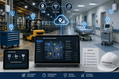
Industrial plants and acute-care hospital facilities have equipment spread across multiple work areas. Staff may need to check different locations before finding the equipment required for a task. Plant and hospital teams may also keep additional equipment or inventory available to meet routine requirements. These conditions can make it difficult to maintain a clear view of asset availability through standard enterprise software alone.
Addressing these persistent inefficiencies requires moving past manual logging and point-in-time barcode scans. Implementing enterprise-grade RTLS allows organizations to capture dynamic movement across manufacturing lines, distribution bays, and clinical units in real time. However, simply installing active tags onto assets does not automatically eliminate workflow bottlenecks or guarantee measurable returns on capital.
Friction in Standalone Location Tracking Deployments
Many internal tracking initiatives struggle because teams approach spatial intelligence as a simple procurement exercise. Operations leaders often purchase packaged hardware kits only to discover that the technology fails to account for heavy structural steel, high-density RF interference, or complex multi-floor transitions. When environmental physics are ignored during the scoping phase, systems produce inaccurate coordinates that undermine user trust from day one.
This lack of technical alignment frequently results in dashboard fatigue, where supervisors are presented with thousands of moving blips on a screen without actionable context. When a location engine cannot distinguish between an asset staging for calibration and one actively utilized on a line, data remains trapped in an isolated silo. Without automated rule sets, teams end up monitoring digital maps rather than solving underlying operational delays.
Architectural Strategy Over Hardware Selection
Matching Tracking Modalities to Physical Realities
RTLS technology can be selected according to the type of tracking required in each part of a facility. UWB is suitable for applications where precise location information is important, such as tool tracking and work-in-progress activities. BLE Angle of Arrival (AoA) and passive RFID can also be used for areas such as storage locations, staging zones, and materials with less frequent movement. The choice can also take into account installation needs and the available budget.
Selecting the appropriate physical layer requires a granular audit of your physical facility, material velocity, and spatial tolerance requirements. Deploying an overly complex system in low-priority zones inflates infrastructure costs, while choosing low-accuracy hardware for high-precision workflows guarantees operational failure. Structuring a hybrid architecture balances capital expenditure against strict physical requirements.
Integrating Spatial Data into Core Enterprise Systems
Location records can be linked with the systems used to manage business and facility activities. ERP, MES, and EHR platforms can receive information related to asset location and movement. Modern architectures must translate spatial events into definitive business status updates without human intervention.
Building this integration bridge requires robust middleware that normalizes incoming telemetry across mixed hardware fleets. Location events can be shared with production, maintenance, and inventory systems when tagged equipment moves through defined areas. These records provide information about physical events and can be used alongside existing operational records.
Mitigating Vendor Bias and Deployment Risk
Hardware vendors naturally design their sales cycles around proprietary tags, fixed reader networks, and exclusive software agreements. This commercial dynamic creates substantial risk of vendor lock-in, leaving facility directors stranded when proprietary components become obsolete or fail to scale into adjacent facilities. Committing to a single hardware vendor before defining your operational workflows limits your future architectural flexibility.
Navigating these technical trade-offs requires experienced technical guidance focused entirely on systemic architecture rather than component sales quotas. Engaging specialized RTLS consulting prior to hardware procurement allows operations executives to benchmark competing RF technologies, define precise data schemas, and validate network readiness against measurable operational outcomes. This objective planning phase eliminates expensive pilot failures and ensures long-term return on capital.
Transforming Spatial Coordinates into Operational Control
LocaXion is the world’s first pure-play RTLS & Digital Twin systems integrator. We engineer systems for your business outcomes-not just “tracking.”
That means less risk, less integration of guesswork, and faster time-to-value. And because we’re not locked to one technology stack, you get the freedom to scale with the right technology – not the technology we happen to sell.
RTLS tracks your assets. LocaXion transforms how your operation runs.
That’s the difference. And it’s not a small one.
Stop managing phantom inventory and disjointed sensor silos and engineer your outcomes today.